
The main task of the Department of Geodesy and Geoinformatics is to organize education in the field of geodetic engineering at the Faculty of Civil Engineering in Belgrade and contribute to science and profession development in the field of geodesy. Apart from that, being the leading institution of this kind at the territory of Serbia, the Department is also tasked with organization of research towards contributing general science development in this field. The Department of Geodesy and Geoinformatics is the parent department in the field of geodetic engineering, namely: Reference geodetic networks, Determination of Earth gravity, Survey and land territory management, Photogrammetry and remote sensing, Geodetic mapping, Land information systems, Geodetic metrology, Geodesy in engineering applications and Modeling and management in geodesy.
The Department of Geodesy and Geoinformatics exists since 1935 in various organizational forms at the Department of Civil Engineering with the Technical Faculty, Belgrade University. Ever since the Department of Geodesy had been established at the Faculty of Civil Engineering in 1947, it provides for all forms of lecturing in the field of geodesy.
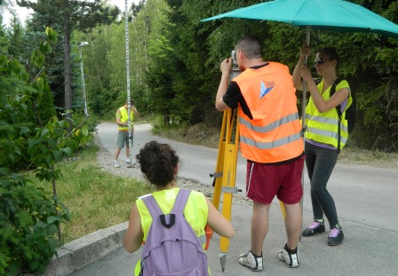
The Department of Geodesy and Geoinformatics organizes and provides education for studies of geodesy and geoinformatics at three levels of study – Undergraduate, Master and Doctoral. The Department has several laboratories at its disposal.
The purpose of undergraduate program is to introduce the students to the methodology of techniques and technologies for geodetic measurements, geospatial data acquisition methods, data processing and analysis technique, using technical documentation and performing governmental and administrative tasks in the field of Real Estate Cadastre. The program lasts for 3 years, providing the professional title: Geodetic Engineer.
The Master academic studies in geodesy have the objective to improve academic competences of the undergraduate students. Course structures at all modules involve specific fields of geodesy, being not only daily engineering practice – complex fields included, which require additional knowledge for comprehending and resolving. Duration of the Master academic studies is two years, with three modules available. Two of the modules are traditionally related to the field of geodesy – Geodesy and Geoinformatics, with separate module being introduced in 2008 – Land management. This module had been established within the separate European Union project, through cooperation with the Universities of Stockholm, Helsinki and Ljubljana. At the completion of Master studies, the Master thesis is being presented, and the graduate title is Master Engineer in Geodesy.
Doctoral academic studies provide students with the capacity for scientific work in research institutions or companies and education work in higher learning institutions. Research work within the Doctoral thesis enables the students for independent organization and management of high-quality, highly original scientific research process and providing scientific contribution in geodesy, along with critical evaluation of other research. Upon finishing the studies, students are awarded scientific title: PhD in Geodesy.
The department has 30 full-time lecturers and associates. Apart from theoretical lecturing, practical training is being organized at special teaching polygons, along with professional internship in geodetic organizations throughout Serbia. The first year enrolment for academic study program covers 40 budget financed and 20 self-financing tuitions for students. When enrolling, rating is being determined upon high school grades and results on mathematics test.